This article was first produced in 2001 for members of the Westcombe Society, Blackheath and the Greenwich Industrial History Society and linked on their original Web sites. In the course of 15 years, this area of East and South-East London has changed dramatically, so where there have been changes, the text has been edited to clarify the route in 2016.
Various newly opened sections of the Thames Path to the Royal Woolwich Arsenal site now make a cycle ride possible virtually ‘off-road’ all the way from either Greenwich Town Centre or from the Westcombe Park area of East Greenwich where this one begins. As well as the new paths on the south side of the ‘water’, local residents, and others, may be interested to hear of an interesting ride just across the Woolwich Ferry, circumnavigating the old Royal Docks and returning to the Ferry.
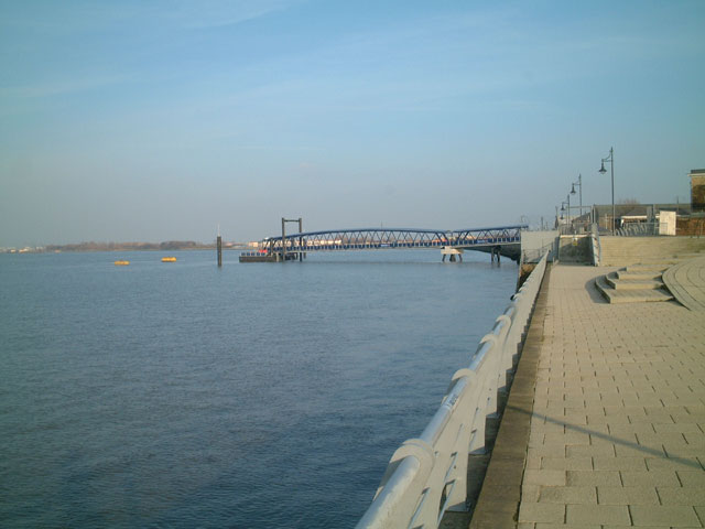
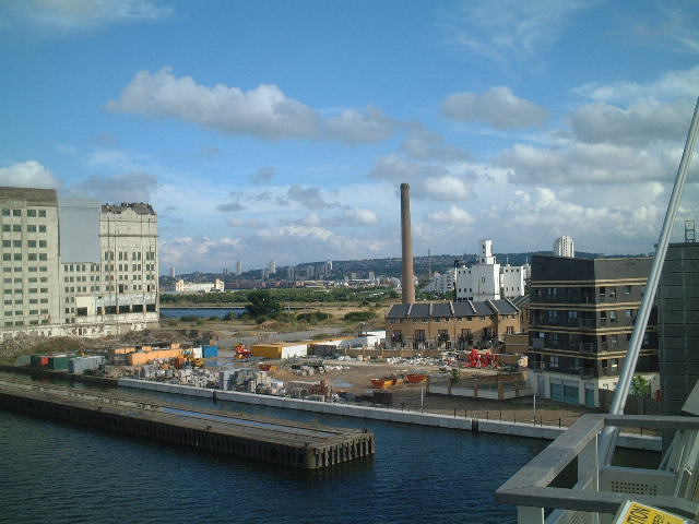
To reach the Ferry from Westcombe Park, SE3, head down to the recently closed Sainsbury’s building on the Greenwich Peninsula using the cycle path from the A102/Woolwich Road flyover. This building, despite being less than 20 years old, is being demolished and is due to be replaced by a new IKEA store. Go straight on, crossing straight over Bugsby’s Way at the roundabout and keep going until you reach the site of the Greenwich Yacht Club at the end of Peartree Way.
Join the Thames Path at this point and follow it to the Thames Barrier without hindrance, passing the huge, active aggregates wharf on the way. If you need an early watering hole, then try the Anchor & Hope a little further along just past the famous Cory Barge Wharf on the way there.
There is currently no news on what is going to happen at the river frontage of the Westminster Industrial Estate just beyond the Barrier. (In late 2015 it was announced that Greenwich Council finally have a solution to this problem in hand that will allow the path to follow the riverfront). At that time it looked as if a pathway is/was being made, but there is/was some new build going on that could potentially block any route at the western end unless the path goes underneath. All the signage at the Barrier currently indicates ‘Interim Route’ for the signposted missing section that currently goes via Woolwich Road. Follow this diversion and rejoin the river path in the middle of the new estate reached by taking the second exit at the next roundabout and following the signs.
After an interesting sculpture at the boundary between the two estates, the path then procedes through the older Woolwich Dockyard Estate and past a pair of old docks now used by a local angling club. Continuing to follow the Thames Path signs then takes you over a new stretch of tarmac laid across Mast Pond Wharf (to the immediate west of the Ferry). This is a bit odd. Some expense has gone into it, yet planning permission for a hotel and housing on this site was approved in 2000, although no building has yet begun.
You can’t miss the Ferry at this point, but if you feel like paying a visit sometime, the new Royal Artillery Firepower Museum is located in the Royal Arsenal just beyond the Waterfont Leisure Centre and Royal Arsenal Gardens located to the east of the Ferry.
Ferry Cross.. the Thames!
Just let the Woolwich Free Ferry take the strain for the next part of the ‘ride’! There never used to be that much to see on this brief nautical venture, although I remember my first views of the area in the late fifties on a passing visit being distracted regardless by some wondrous massive and noisy machinery exposed on the old steam ferries themselves. However, these days, on a more boring diesel vessel, one can take a fresh perspective on the Royal Arsenal Gardens and Riverside Walk in front of some of the newly refurbished Royal Arsenal buildings and the new flats reaching skywards adjacent to the old main lock at the extreme eastern end of the Royals.
The (then) newly opened Woolwich Pier serving the Royal Arsenal
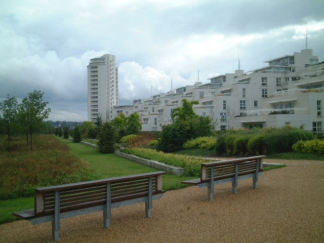
On leaving the Ferry and initially following the signs to Beckton and the North Circular Road, just before the main North Woolwich Road, turn right in to the Royal Victoria Gardens.
Royal Victoria Gardens
These are something of a surprise. Historically the location of great Victorian Fêtes and Galas, and probably past their best, they are nevertheless still well looked after and popular with the locals. There is a bowling green, children’s paddling pool and play area and plenty of green sward. A high-level walk/cycle-way runs parallel to the river. Leave the Park at the eastern end, re-join the Woolwich Manor Way and stop on the first bridge, located over the old locks. The bridge lies immediately above a Watersports and Jet-Ski Centre whose water extends along the entire southern side of the London City Airport runway.
Watersports Centre, LCA runway and UEL campus
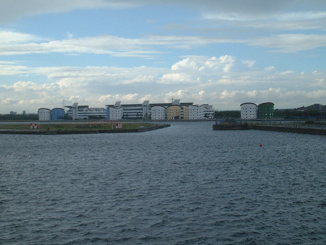
To the north of the runway is the newly established rowing regatta course belonging to the Royal Docks Rowing Club (now The London Regatta Centre and home of the Curlew Rowing Club). Continue along Manor Way over a further new bridge. To the right lies the new headquarters building of Norton Healthcare. At the large roundabout, turn left towards the main spine road. Almost immediately bear left in to the grounds of the new Docklands Campus of the University of East London.
UEL
Don’t let the security guards put you off… they don’t bite and access is permitted at all times. Initially passing by a large car park, bear left as soon as possible to the dockside path. The circular multi-coloured buildings adjacent to the Dock are student residence blocks. If you are nosy enough to peer in through a window (preferably out of term time!), you will observe the interesting triangular-shaped rooms that such an external feature determines. I’m not sure these are actually very practical! Follow the path along past the gardens to the ‘Quad’. There are some of the usual Campus facilities here including bars and restaurants, although these are usually only open during the week in term time. Taking either the staircase to the right of the pedestrian underpass, or the unofficial short cut out through the corner of a small car park at the north-west corner to the left, return to the Spine Road. Unfortunately, at the time of writing, the dockside path was closed over the section down to the next roundabout.
London City Airport
Take a left once you reach this and return via a smaller roundabout and paved play area to the dockside. On my visit there was a very organised group of teenagers playing roller hockey, complete with nets, adult referees and a ‘barbie’ open to all. If you feel like a rest, there are some seats here where you can look across the water at the comings and goings at the Airport. Turnaround times are amazing… sometimes a mere 20-30 minutes, but that is apparently the way of the aviation world these days, and a sheer necessity at London City where there are only a dozen or so bays. Be aware that operations are limited at weekends, and only start up seriously around 4pm in the afternoon.
Rowing Club (London Regatta Centre)
Moving on to the west one arrives at the Club House of the Rowing Club. This has a large restaurant on the first floor which is open to the public. I have yet to witness any events at the Club, or even any training in progress, so I can only assume that Sunday afternoon is not the time it is done. Carry on under the bridge that separates Royal Albert and King George V Docks from Royal Victoria Dock. Over on the far side is a Kart Track that is worth a visit if there is any noisy action in progress. Staying on the north side and sticking as close to the dockside as the current paths permit, you will need to negotiate an area of fly-tipping on an unused road. On the far side of this and again keeping left, return to the dockside by entering the Eastern Car Park of the Excel Exhibition Centre.
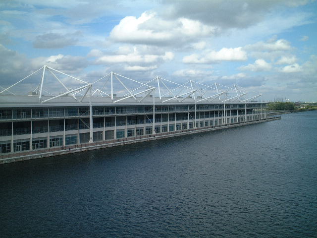
Excel
This impressive structure offers exhibition halls of a range of size on either side of a central aisle featuring the usual catering and support facilities associated with such enterprises.
 4
4
The Excel Exhibition Centre
The entire frontage of the building on the ground floor features a series of conference suites, again to suit all requirements. Having attended just one exhibition so far, my sole objection to the design is the fact that all the halls are totally devoid of natural light, which is such a big feature of Olympia’s National Hall for instance. Things are not going as well as expected for the venue at present, but they do have the prospect of the Boat Show moving from Earl’s Court in 2004 to look forward to. Although an interesting prospect if it were to be rescheduled for the summer, the idea of skimpily clad models cavorting on open decks along the dockside in mid-winter gives me the shivers, let alone concern for all the pilots trying to concentrate on their runway approach!
Shades of the ‘Pyramide du Louvre’ in Paris?
At the western end of the building is a glass pyramid entrance hall along the lines of the Pyramide du Louvre in Paris. It looks out on to a grassy area with computer-controlled fountains sunk in to a flat, paved area. Try keeping your kids out of that lot in the summer!
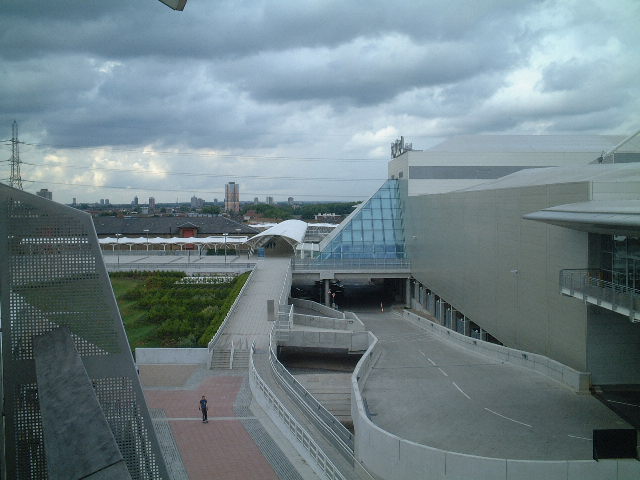
Millennium Bridge
Adjacent, on the dockside is a new, high-level bridge that provides a vital link between the DLR station at Cyprus, which also serves the Excel Centre, and the new Canning Town Britannia Village complex.
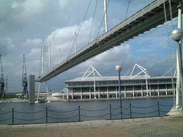
The Millennium Bridge
Spend a moment climbing the stairs or taking the lift, and go half-way across. The views are spectacular to the west in particular where you are right on the Canary Wharf/Dome line, whereas to the east you are directly on the flight path of the Airport. Stay there long-enough and you might experience being directly beneath an incoming flight approaching from the West on what is said to be the most spectacular approach of any airport in Europe.
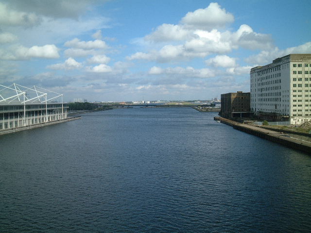
Looking east towards London City Airport
There follows a section of blue hoarding which surrounds the proposed hotel facility for Excel. Building is not yet underway (summer 2001), but is promised in the next Phase. You have now reached almost the extreme western end of the Royals.
The home of windsurfing
This ‘short’ side of the dock is occupied by Newham Council’s Watersports Centre and an old sailing barge which has been converted in to a pub/club.
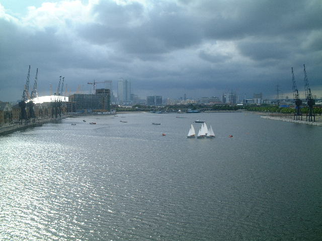
Sailing on Royal Victoria Dock
It was originally the clubhouse of the Peter Chilvers’ Windsurfing Centre. Peter Chilvers is credited with having introduced windsurfing to the UK, and there used to be a significant presence of the craft on the Royal Victoria when it first converted to leisure use, but the popularity of this sport appears to have waned for some reason in recent years. There is a very well-designed graded shingle beach occupying the old western lock entrance next to the barge where wind-surfers can be launched very easily. Permits are available from the Watersports Centre. Winds in the dock always used to be quite fluky when I last tried it, and I doubt that much has changed with the old warehouses having given way to Excel and dockside maisonettes.
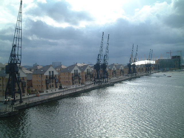
1960s cranes retained and the new Village
Old and New
There are bits of industrial history all around here. Old pumping stations for the locks, new award-winning multi-coloured Thames Water pumping stations, derelict flour mills, some of the last cranes to be installed in the London Docks in the early sixties as well as, further on, the huge and still operational Tate & Lyle Sugar Refinery. This building was used as the centrepiece for Jean Michel-Jarre’s 1988 concert Destination Docklands that was performed over two nights and had according to the event Web site sold 400,000 tickets for the two nights. Riverside, it also features one of the deepest wharves upstream of the Barrier, recently dredged out still further.
Old pumping station and flour mills
Our journey now starts back to the Ferry. Continue along the dockside in front of the new Village. This will take you as far as the southern end of the Bridge where there is a small group of shops and businesses including an Internet Café! Go under the arch, then through a small car park. On reaching the main Village service road, turn left. Go to the end where there is a roundabout, and turn right moving on until you reach Silvertown Way, now the southern ‘spine road’. Turning left again, there is a footpath cycle-way separated from the main carriageway by bushes. When you start to see the road again you should be almost opposite a large new Barrett’s Homes development which looks remarkably like Excel. It is oriented at right-angles to the river and is adjacent to the first major new Park to be opened in London for many years.
Barrett Homes development and Barrier Park
Barrier Park
This well-kept secret occupies the area between Silvertown Way and the Thames, just upstream from the Barrier. Appropriately known as Barrier Park, it is something of a revelation. If you should choose to pay a visit here by car, a decent sized parking area is located next to a Café and performance area. One of the main events of the 2001 Greenwich and Docklands Festival was held here. A large and spectacular formal garden runs parallel with the Barrett flats, for the whole length of the Park. On reaching the riverside there is an elegant wooden shelter and boardwalk area as well as a gravel river-walk and at long last… some seating! This is the one thing missing in large parts of the Park. Although there are plenty of grassy areas for picnics, sunbathing or whatever, seating is at a premium.
The Thames Barrier is always worth looking at from any angle, and this is a perspective you may well not have had the opportunity of seeing previously. Most of the eastern side of the Park is much more informal with trees and the ground cover left as meadow. There is also a large, children’s play area. Let’s hope it doesn’t get vandalised too rapidly. All in all, something of an eye-opener for this part of London, built as it is on a previously derelict industrial site.
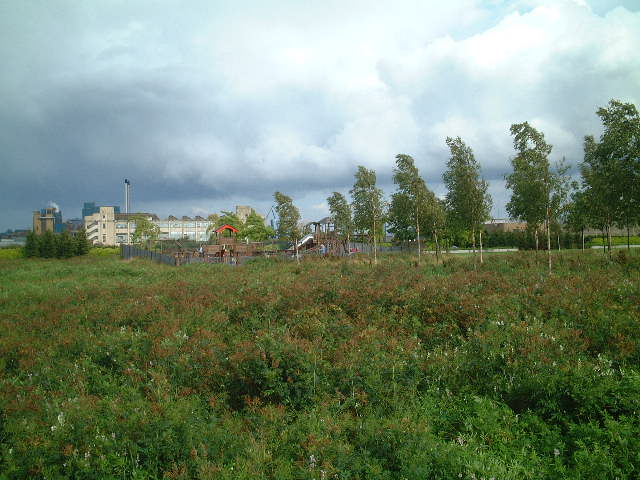
Play area and meadows
The Boring Bit
The final part of the trip is the least interesting. There are no river-front options that I could find, like the Thames Path on the south bank of the river, so the closest you can get to the shoreline means following the footpath/cycleway to the south of Silvertown Way. After reaching the ‘Airport’ roundabout at the southern end of the road bridge across the Royals, bear right, along Factory Road to the south, and parallel with, the currently dead-end North Woolwich Line around the back of the afore-mentioned Tate & Lyle’s. Head back towards the River at the first opportunity and then keep going left towards the huge dishes of BT’s Satellite Communications Centre which are located just upstream of the Woolwich Ferry.
I was just in time to catch the last ferry back to Woolwich. Watch out for this. They officially stop at 7.45pm at the weekend, but it was not quite as late as this, yet there were no more that day for sure. If you get caught out, don’t forget that there is always the Woolwich Foot Tunnel as a back-up plan. Greenwich’s twin, this will also take you back across the river to emerge alongside the Waterfront Leisure Centre in Woolwich.
All text & images copyright David Riddle 2001/2016
